Hyderabad Metro Extension: 40 km Airport-Fourth City Line to Boost Connectivity
In a press release, HAML confirmed that the Chief Minister has approved the broad layout for the Metro Phase II corridors, which will include several new lines
Hyderabad: A new Metro Rail line is being planned to connect the Rajiv Gandhi International Airport (RGIA) in Shamshabad to the upcoming Fourth City via Mansanpally Road and the Outer Ring Road (ORR) stretch between Pedda Golconda and Raviryal exits. The total length of the Metro line will be 40 km, starting from the airport and extending to Skill University in the proposed Fourth City.
The Hyderabad Airport Metro Limited (HAML) announced that the metro corridor will include approximately 2 km of underground tracks within the airport premises, 20 km of elevated tracks, and an 18 km ‘At Grade’ (road-level) section from the ORR Raviryal exit to Skill University. This section will be part of a new 300-foot-wide greenfield road.
HAML Managing Director NVS Reddy, who presented the project details to Telangana Chief Minister A. Revanth Reddy, revealed that the alignment of the airport metro has been finalized to pass through Aramghar and the new High Court area on National Highway 44 before reaching Shamshabad Airport.
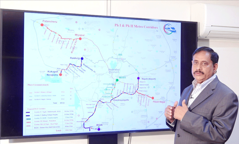
In a press release, HAML confirmed that the Chief Minister has approved the broad layout for the Metro Phase II corridors, which will include several new lines:
- Nagole to RGIA (Airport Corridor)
- Raidurg to Kokapet Neopolis
- MGBS to Chandrayangutta (Old City Corridor)
- Miyapur to Patancheru
- LB Nagar to Hayat Nagar
- RGIA to Fourth City (Skill University)
The entire Metro Phase II project is expected to cost approximately ₹32,237 crore, including ₹8,000 crore specifically allocated for the airport to Fourth City corridor. The project will be implemented as a joint venture between the Telangana state government and the Government of India.
The Nagole to RGIA corridor, spanning 36.6 km, will connect multiple points in the city, including LB Nagar, Karmanghat, Owaisi Hospital, DRDO, Chandrayangutta, and Mailardevpally, before reaching Shamshabad Airport. Out of the total distance, 35 km will be elevated, with a 1.6 km underground section, and the route will feature 24 metro stations.
The Raidurg to Kokapet Neopolis Corridor will cover 11.6 km with eight stations, passing through important areas such as Biodiversity Junction, Khajaguda, and the Financial District.
The Old City Corridor (MGBS to Chandrayangutta) will extend the Green Line from MGBS, passing through historic areas like Shalibanda and Falaknuma, with a focus on maintaining heritage structures along the route.
Additionally, the Miyapur to Patancheru Corridor will stretch 13.4 km, extending the existing line from Miyapur and covering areas like Alwyn Crossroad, Madinaguda, and BHEL.
The LB Nagar to Hayat Nagar Corridor will span 7.1 km, connecting key locations on the city’s outskirts.
HAML MD NVS Reddy mentioned that preparations for metro connectivity to the Fourth City will soon be submitted to the Government of India for final approval.
Metro Phase II Corridors at a Glance:
- Corridor IV: Nagole – RGIA (Airport Corridor) – 36.6 km
- Corridor V: Raidurg – Kokapet Neopolis – 11.6 km
- Corridor VI: MGBS – Chandrayangutta (Old City Corridor) – 7.5 km
- Corridor VII: Miyapur – Patancheru – 13.4 km
- Corridor VIII: LB Nagar – Hayat Nagar – 7.1 km
- Corridor IX: RGIA – Fourth City (Skill University) – 40 km
- Total Length: 116.2 km
This massive metro expansion aims to enhance public transportation in Hyderabad, easing traffic congestion and providing faster connectivity to key parts of the city, including the airport and the rapidly developing Fourth City.